


Handy GPS lite

Handy GPS lite介绍
您下次户外探险的完美伴侣。使用 Handy GPS 寻找、查找、记录并返回家。无需用户帐户或设置 - 只需安装它,打开 GPS 即可出发!
该应用程序是一款功能强大的导航工具,专为徒步旅行、丛林徒步、徒步旅行、山地自行车、皮划艇、骑马和寻宝等户外运动而设计。它对于测量、采矿、考古和林业应用也很有用。它使用简单,即使在最偏远的偏远地区也能工作,因为它不需要网络连接。它允许您在 UTM 或纬度/经度坐标中工作,因此您甚至可以将其与纸质地形图一起使用。
注意:这是免费试用版,仅限于存储 3 个航路点和 40 个航迹记录点。您可以无限期地使用试用版,但如果您喜欢这个应用程序,请安装付费版“Handy GPS”以获得具有更多功能的无限制版本。谢谢!
此外,允许应用程序始终使用 GPS,并关闭应用程序的电池优化功能,以便在手机屏幕关闭时可靠地记录轨迹日志。
基本特点:
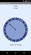
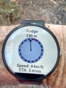
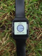
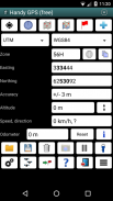
* 显示您当前的坐标、高度、速度、行进方向以及以公制、英制/美制或航海单位表示的总行进距离。
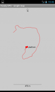
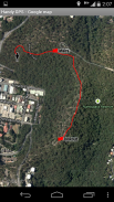
* 可以将您当前的位置存储为航点,并记录轨迹日志以在地图上显示您去过的位置。
* 数据可以从 KML 和 GPX 文件导入和导出。
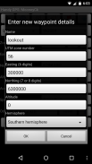
* 允许手动输入 UTM、MGRS 和纬度/经度坐标中的航路点。
* 可以使用“Goto”屏幕引导您到达航路点,并且可以选择在您接近时发出警报。
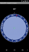
* 有一个指南针页面,适用于带有磁场传感器的设备。
* 自动计算当地大地水准面偏移量以提高高度精度
* 支持全球 WGS84 基准以及常见的澳大利亚基准和地图网格。在美国,您可以将 WGS84 用于 NAD83 地图。
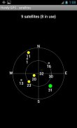
* 以图形方式显示 GPS 卫星位置和信号强度。
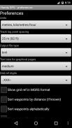
* 可以显示简单或MGRS网格参考。
* 可以计算航点到航点的距离和方向。
* 包括可选的计时器线,用于记录步行持续时间并计算您的平均速度。
* 开发商在许多越野行走中进行了全面测试
付费版本独有的额外功能:
* 无广告。
* 无限数量的航路点和航迹记录点。
* 离线地图。
* 自定义数据。
* 海拔剖面。
* 通过应用程序拍照并录制语音备忘录。
* 通过电子邮件或短信将您的位置发送给朋友。
* 英国电网参考。
* GPS 平均以提高定位精度,
* 日出和日落时间。
* 将航点和轨迹日志导出到 CSV 文件。
* 使用方位和距离投影航路点。
* 根据轨迹记录计算长度、面积和海拔变化。
* 计算卡路里。
权限:(1) GPS - 确定您的位置,(2) 网络访问 - 用于访问标准地图图层和 OSM 图块,(3) SD 卡访问 - 加载和存储航路点和轨迹日志,(4) 用于拍摄的相机访问图片*,(5) 防止手机休眠,以便接近警报起作用,(6) 控制手电筒,以允许从应用程序内打开/关闭手电筒,(7) 录制语音备忘录的音频*。 (* 功能仅在完整版应用程序中可用)。
免责声明:您使用此应用程序的风险由您自行承担。开发者对您因使用此应用程序而迷路或受伤不承担任何责任。移动设备的电池可能会没电。对于长途和偏远的徒步旅行,为了安全起见,建议使用电池组和替代导航方法,例如纸质地图和指南针。
Handy GPS lite - 版本42.8
(21-11-2024)
Handy GPS lite - APK信息
APK版本: 42.8程序包: binaryearth.handygpsfreeHandy GPS lite的最新版本
其他版本


同类应用


